
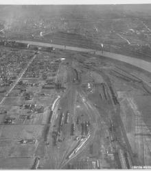
Circa 1930 photograph with an aerial view of a residential area and rail yard with roundhouse near the Kansas River in the Argentine neighborhood. This vantage point faces northwest and shows Armourdale to the right of the river.
Rivers
Displaying 25 - 36 of 41
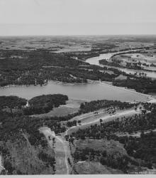
Circa 1930 photograph with an aerial view of Lake Quivira. Work on the lake and the surrounding area was started by the Quivira Development Company in 1927. The first stages of the project were completed by the early 1930s. This vantage point faces west with the Kansas River in the right background.
Circa 1930 photograph with an aerial view, looking east, across the Armourdale district and towards the Kansas River.
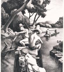
A lithograph on paper by Thomas Hart Benton depicting four young fisherman in two boats on a small river. This representational print was created while Benton taught at the Kansas City Art Institute. The original dimensions are 12 1/2 x 10 in. (31.8 x 25.3 cm).
Photograph of "Hell’s Half Acre", an area in the late 1800's and early 1900's consisting of the north side of the West Bottoms between the bluffs and the state line. This vantage point faces northwest from the bluffs near 7th Street and shows 8th Street between Mill Street (now Madison Avenue) and Sante Fe Street.
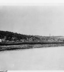
Photograph of Argentine and Shawnee Heights, two sections of Kansas City, Kansas, as seen from the Kansas River. The large building pictured center is the Franklin School on Metropolitan Avenue between S 14th and 15th Streets. This picture was taken before 1923 when the building received a four-classroom addition.
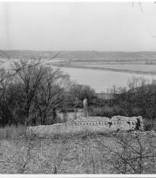
Photograph with view of Quindaro ruins located in Kansas City, Kansas. Missouri River is visible in the background. Town of Quindaro was built in 1857. This vantage point faces north and shows the Missouri River in the background.
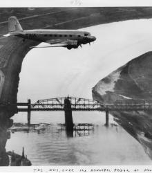
Photograph of a Douglas Commercial DC-1 airplane flying north over the Missouri River. This vantage point faces west-southwest with the Hannibal Bridge and the West Bottoms (top-background) pictured.
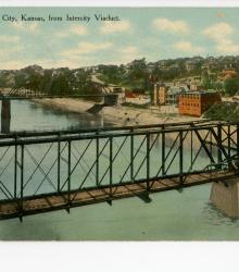
Postcard showing the Intercity Viaduct (foreground), James Street (background), the Kansas River (left), and Kansas City, Kansas (right). This vantage point faces southwest from a railroad bridge northeast of the Intercity Viaduct. The back of the postcard includes a short letter to Mrs. Lee Moore of Lock Springs, Missouri.
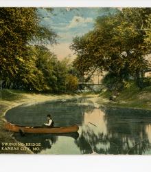
Postcard showing the Blue River and Swope Park Swinging Bridge, located to the southwest of The Lagoon in Swope Park, Kansas City, Missouri. This vantage point faces north-northwest towards the bridge on the Blue River. The back of the postcard includes a short letter to William B. Walker of Vancouver, Washington.
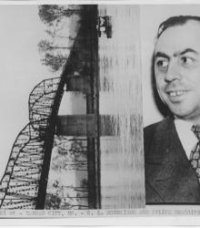
Photograph of Edward L. Schneider attached to a photograph of police searching for Schneider's body at the bottom of the Missouri River with nets. Schnider went missing after testifying against Thomas J. Pendergast. The caption reads, "Chi 27 - Kansas City, Mo. - E. L. Schneider and police dragging river."

Photograph of the Blue River north of St. John Avenue. The picture was taken looking northeast towards the Missouri Pacific Railroad bridge during a hike to Jesse James Cave on the Missouri River bluff near Sugar Creek, Missouri.