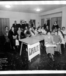
Photograph showing an interior view identified as "Adult Education English Class, Guadalupe Center, 1015 W. 23, Kansas City, Mo., Dec. 3, 36." Individuals not identified.
West Side South
Displaying 13 - 24 of 40
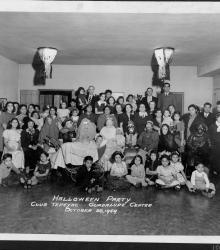
Photograph with interior view identified as "Halloween Party, Club Tepeyac, Guadalupe Center, October 28, 1939." Many in photograph are in Halloween costume. No identification of individuals.
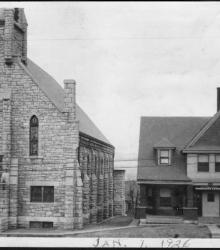
Photograph of the Amberg Club's Guadalupe Center Settlement House (right) and Our Lady of Guadalupe Catholic Church (left). This vantage point faces south from the northwest corner of the intersection of 23rd Street (now Avenida Cesar E Chavez) and Madison Avenue.
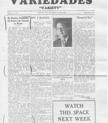
5th issue of Kansas City Mexican-American newspaper Variedades. In the featured story, the editor calls for Conrad H. Mann to collaborate with Mexico as part of Kansas City's Ten Year Plan. Other articles detail the history of Memorial Day and provide news concerning the local Kansas City Mexican-American community.
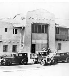
Photograph of people and vehicles outside the Guadalupe Center in Kansas City, Missouri's Westside neighborhood. The organization, founded in 1919, provided healthcare, education, and other services to the local Mexican immigrant population who had moved to Kansas City for jobs with the railroads and packing houses.
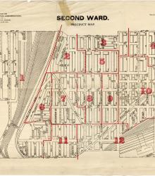
Map showing the boundaries of precincts as defined in 1918 for the second ward of Kansas City, Missouri. This ward is bounded by 14th Street to the north, Kansas to the west, 24th Street to the south, and Grand Avenue (now Grand Boulevard) to the east.
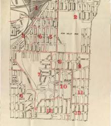
Map showing the boundaries of precincts as defined in 1918 for the third ward of Kansas City, Missouri. This ward is bounded by 24th Street to the north, Kansas to the west, 39th Street to the south, and Main Street to the east.
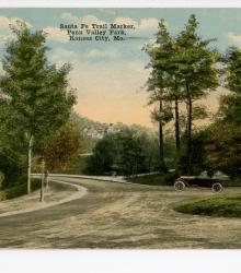
Postcard showing the Santa Fe Trail Marker inside of a roundabout near Broadway and 30th Street in Penn Valley Park, Kansas City, Missouri. This vantage point faces southeast from just north of the roundabout, which is located west of Broadway Boulevard at the intersection 30th Street and Penn Drive.
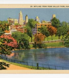
Postcard showing the Kansas City skyline from near the Penn Valley Park lake. This vantage point faces north towards downtown Kansas City, Missouri. The back of the postcard includes a brief caption about the postcard and a short letter to Mr. and Mrs. Hugh Robertson of McFall, Missouri.
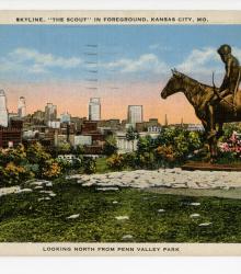
Postcard showing the Kansas City, Missouri skyline with The Scout Statue in the foreground, located in Penn Valley Park between Penn Drive and Summit Street. This vantage point faces north-northeast past The Scout Statue and towards the downtown skyline. The back of the postcard includes a brief caption about the statue and a short letter to N.
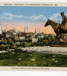
Postcard showing the Kansas City, Missouri skyline with The Scout Statue in the foreground, located in Penn Valley Park between Penn Drive and Summit Street. This vantage point faces north-northeast past The Scout Statue and towards the downtown skyline.
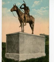
Postcard showing The Scout Statue, located in Penn Valley Park between Penn Drive and Summit Street. This vantage point faces east towards The Scout Statue. The back of the postcard includes a short letter to Mrs. P. H. Colborn of Kansas City, Missouri.