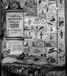
Comic-style drawing depicting the fox hunting community in Johnson County, made as a gift for Joe and Steve Stubbs by Frank Huston, circa 1937. Homes and farms belonging to members and sites of hunts are depicted. Members of the Mission Valley Hunt Club, including Marguerite Peet, H. O. Peet, O. J. Bitler, and Joe Mackey are listed.
Maps
Displaying 1 - 12 of 42
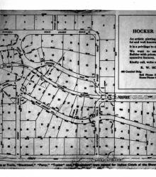
Plat map illustrating available lots for development in the Hocker Grove subdivision in Merriam, Kansas, circa 1915. The subdivision, between 55th Street on the north and Johnson Drive (then Main Street) on the south, was located west of Turkey Creek and developed by Richard W. Hocker.
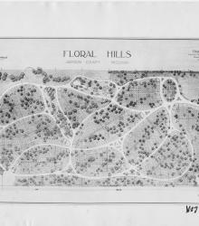
Photograph of an architectural drawing of Floral Hills cemetery, drawn by Hare & Hare, a landscape architecture firm. The cemetery is located north of 71st Boulevard (Gregory Boulevard) between James A. Reed Road and Blue Ridge Extension (Blue Ridge Boulevard).
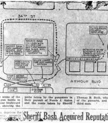
Map of the shootout between police and gangsters on the morning of August 12, 1933. The caption states, "A diagram of the scene of the Saturday morning gun battle in the vicinity of Amour boulevard and Forest avenue, showing the paths taken by the gangsters in their pursuit of Ferris J. Anton and the route taken by Sheriff Thomas B.
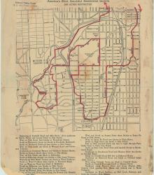
Street map of a "Scenic Route Through the Country Club District: America's Most Beautiful Residential Section, 2000 Acres Restricted." The scenic route is indicated in red; specific directions are at bottom of map. Map shows Kansas City Country Club, Mission Hills Country Club, and names of neighborhoods.
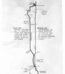
Map of the proposed Brookside Extension to aid in the commute from the Country Club District to downtown Kansas City, Missouri.

Street map of Kansas City, Missouri showing parks, cemeteries, boulevards, city limits, railroads, park district boundaries, and street car lines.
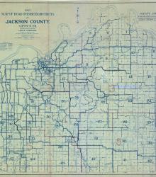
Map of Jackson County, Missouri, indicating surface conditions of roads, plus railroads, electric lines, streams, etc. Under title of map: "Leo E. Koehler. County Surveyor and Ex-officio County Highway Engineer of Jackson County, Missouri."
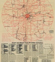
Broadside including two road maps: one with an approximately 115 mile radius around Kansas City; and one of the Kansas City metropolitan area. The text of the broadside emphasizes the need for good roads in and around Kansas City so that the region can be competitive in agriculture.
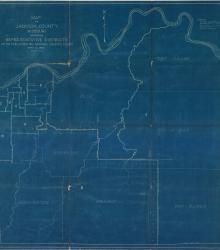
Map of Jackson County, Missouri showing representative districts as established by Jackson County Court, May 2, 1922. The map shows district and municipal township boundaries, city limits, sections lines and rivers.
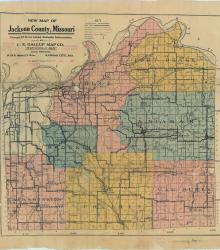
Map of Jackson County showing roads, railroad lines, streams, schools, and churches. Townships are shown in color.

Kansas City, Missouri, color-coded zoning map of nine zone classifications, including residence, retail, and industrial zones. "Information taken from city ordinance No. 45608 and the latest official data of City Plan Commission."