An excerpt of John Q. Adams's doctoral thesis about the physical and cultural characteristics of the North Kansas City Urban District. Adams characterizes the district both as a unit and in relation to Kansas City, Missouri across the river. He concludes his study with a discussion of the implications for future changes in the landscape.
North Kansas City
Displaying 1 - 12 of 14
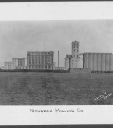
Circa 1928 photograph with distant view of Monarch Milling Company facility. Little Princess Flour sign on building as well as Commander-Larabee Corp. This vantage point faces east near the defunct intersection of Lydia Avenue and Armour Road. The facility was demolished in 2012.
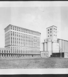
Circa 1928 photograph with frontal and side view of the Monarch Milling Company. Sign on side says King of Kansas Flour. This vantage point faces southeast near the intersection of Flora Avenue (presently Quebec Street) and Armour Road. The facility was demolished in 2012.
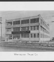
Circa 1928 photograph with full frontal and partial side view of the Waggener Paint Company associated with Pratt & Lambert, Inc. It was once located at the southeast corner of 10th Avenue and Burlington Street in North Kansas City.
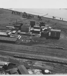
Circa 1930 photograph with an aerial view of the Corn Products Refining Company near the intersection of 10th Avenue and Bedford Avenue in North Kansas City, Missouri. This vantage point faces southeast and shows the Missouri River (background) and the Kansas City Car Company (left foreground).
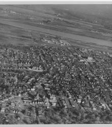
Circa 1930 photograph with an aerial view looking east and showing a largely residential section of northeast Kansas City, Kansas; Fairfax; Missouri River; and North Kansas City, Missouri. Quindaro Boulevard is prominently shown diagonally in the photograph.
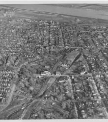
Circa 1930 photograph with an aerial view of northeast Kansas City, Kansas. This vantage point faces east and shows the area that will eventually be remade as Jersey Creek Park.
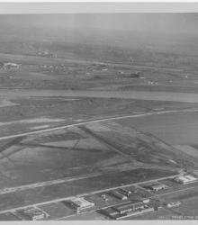
Circa 1930 photograph with an aerial view, looking east, of Fairfax Industrial and Municipal airports.
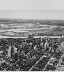
Circa 1930 photograph with an aerial view of downtown Kansas City looking northwest, taken over near 15th Street and Grand Avenue. Shows Missouri River, Municipal Airport, 2nd Hannibal Bridge, and ASB Bridge.
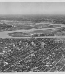
Circa 1930 photograph with an aerial view looking northwest toward downtown Kansas City taken over near 18th and Harrison streets. Shows the confluence of the Kansas and Missouri Rivers, Municipal Airport, and Fairfax area.

Map of a stretch of the Missouri River from Quindaro Bend and the Fairfax Drainage District to the East Bottoms Bend. Shows all principal topographic features for a minimum distance of 2000 feet inland, indicating levees, jetties, creeks, and railroad lines.
Circa 1925 photograph with full, street corner view of Quayle Methodist Episcopal Church located at the northeast corner of 21st and Iron streets in North Kansas City, Missouri.