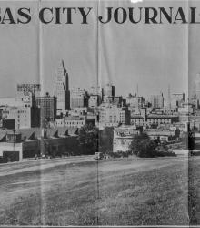
Clipping from the Kansas City Journal-Post on September 29, 1935 showing downtown Kansas City. This vantage point faces north-northwest from the east side of Gillham Road between 23rd Street and 24th Street. The photograph shows the Kansas City Journal-Post Building (left-center) and the Western Auto Building (left).
Crown Center
Displaying 49 - 60 of 131
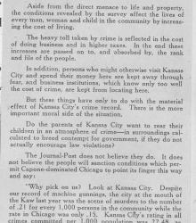
Clipping from the Kansas City Journal-Post on February 11, 1931 in which the editor describes the economic and moral implications of high crime in Kansas City and provides crime statistics. The Journal-Post resolves to "change these conditions".

Clipping from the Kansas City Journal-Post on November 5, 1930 showing how many votes each candidate received from each ward in Kansas City in the election the day previous.
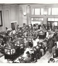
Photograph of an interior view of customers and waitresses at the Atchison, Topeka & Santa Fe Railway Company's Fred Harvey House in Union Station, Kansas City, Missouri. Over 9,000 meals were served at the restaurant in a 24-hour period.
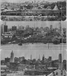
Clipping from the Kansas City Journal-Post with caption stating, "Twenty Years of Skyline Change in Kansas City. These three photographs taken from virtually the same spot on Journal-Post hill show the amazing growth of this city's business district in a score of years. The upper picture was made in August, 1912.
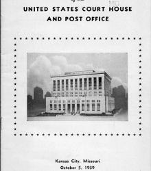
Program from the edication ceremony of the new United States Court House and Post Office on Pershing Road. Federal judge Merrill E. Otis presided over the event, with guests including Senator Bennett "Champ" Clark, Senator Harry Truman, and Governor Lloyd C. Stark.
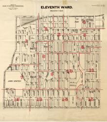
Map showing the boundaries of precincts as defined in 1918 for the eleventh ward of Kansas City, Missouri. This ward is bounded by 20th Street to the north, Grand Avenue (now Grand Boulevard) to the west, 31st Street to the south, and Michigan Avenue to the east.
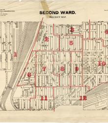
Map showing the boundaries of precincts as defined in 1918 for the second ward of Kansas City, Missouri. This ward is bounded by 14th Street to the north, Kansas to the west, 24th Street to the south, and Grand Avenue (now Grand Boulevard) to the east.
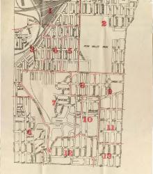
Map showing the boundaries of precincts as defined in 1918 for the third ward of Kansas City, Missouri. This ward is bounded by 24th Street to the north, Kansas to the west, 39th Street to the south, and Main Street to the east.

Postcard showing the lobby at Union Station in Kansas City, Missouri. This vantage point faces north towards the entrance of the main waiting room from near the southwestern corner of the lobby. The back of the postcard includes a short letter to Emma McFarland of St. Louis, Missouri.
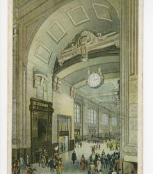
Postcard showing the entrance to the main waiting room in Union Station in Kansas City, Missouri. This vantage point faces northwest towards the entrance from within the Grand Lobby. The back of the postcard includes a short letter to Mrs. Nick Woods of Deepwater, Missouri.
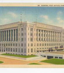
Postcard of the General Post Office in Kansas City, Missouri. The building now houses the Kansas City Internal Revenue Service (IRS). This vantage point faces southeast towards the Federal Post Office on Pershing Road. The back of the postcard includes a short letter to Bessie Tucker.