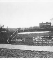
Photograph with caption, "where Brookside Boulevard Extension would come northwest to 47th Street through Park Land." This vantage point faces south from just south of the intersection of Main Sreet and 47th Street.
Westport
Displaying 61 - 72 of 515
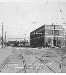
Photograph with caption, "looking east on 48th Street toward Troost Avenue." This vantage point faces east-northeast from the intersection of 48th Street and Harrison Street and shows a K. C. Railways Co. building.
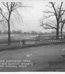
Photograph with caption, "looking northeast from 55th and Summit Streets toward Wornall Road." The photograph's annotations label streets and show proposed road improvements.
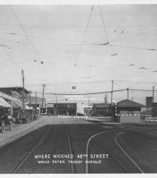
Photograph with caption, "where widened 48th Street would enter Troost Avenue." This vantage point faces east-northeast on 48th Street between Harrison Street and Troost Avenue.
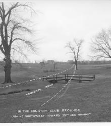
Photograph with caption, "in the Country Club grounds looking southwest toward 55th and Summit." The photograph's annotations show a proposed road.

Photograph with caption, "proposed trafficway in 48th Street looking west from Oak Street."
Circa 1930 photograph with an aerial view looking northeast at the intersection of Ward Parkway and State Line Road, showing the campus of Pembroke Country Day School and Brush Creek.
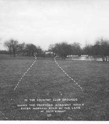
Photograph with caption, "in the Country Club grounds where the proposed roadway would enter Wornall Road by the lake at 5nd Street." This vantage point faces northeast near the center of present day Loose Park.
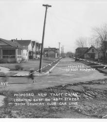
Photograph with caption, "proposed new trafficway looking east on 48th Street from Country Club Car Line."
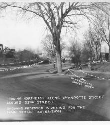
Photograph with caption, "looking northeast along Wyandotte Street across 52nd Street showing proposed widening for the Main Street extension." Several homes, a woman, and a child riding a tricycle on the sidewalk are shown.
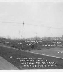
Photograph with caption, "The Main Street hump north of 49th Street is high above the playground of the E. C. White School. The picture shows a proposal to cut 6 feet of elevation of Main Street to a grade of 4.18%. This vantage point faces northwest from the north side of 49th Street between Main Street and Walnut Street.
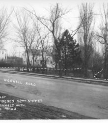
Photograph with caption, "looking east where widened 52nd Street would connect with Wornall Road." The photograph's annotations label streets and show proposed road improvements.